Research Team:
Insitution: Coastal Carolina University
Start Date: August 1, 2022 | End Date: July 31, 2025
Research Theme: Community Water Modeling
Accurate prediction and forecasting of coastal processes such as flooding are crucial for water resources, public safety, disaster planning, and resilience. Flooding arises from multiple interconnected factors, including heavy rainfall runoff from inland upstream rivers, storm surges pushed onshore along the coast, and normal tidal fluctuations. Often these factors compound and interact to create substantially worse floods than any one in isolation. This research links models of inland river basins with models of coastal ocean dynamics to better represent these compound flooding effects.
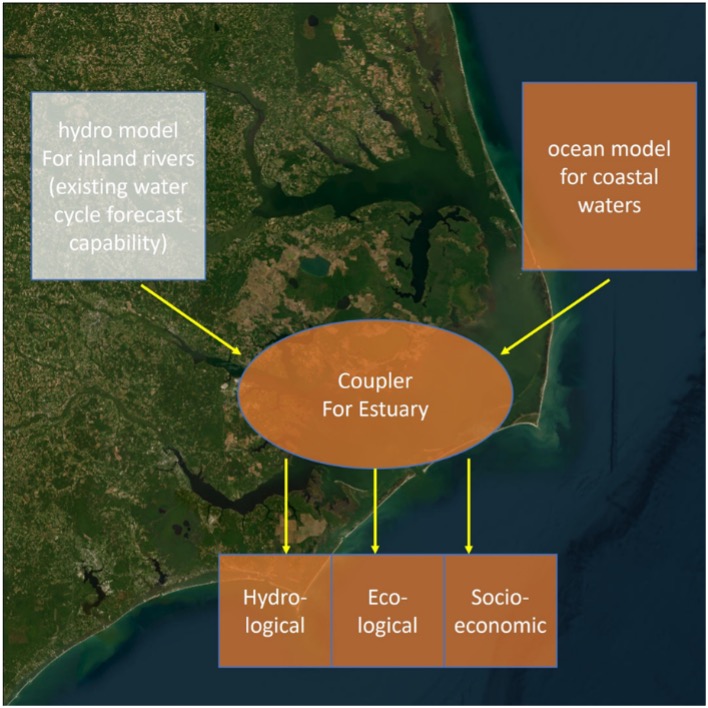
The core inland model is the National Water Model (NWM), developed by the National Oceanic and Atmospheric Administration (NOAA) to provide streamflow forecasts and flood prediction across the continental United States. The coastal model used in this study is the SCHISM model, focused specifically on the shoreline and estuaries of South Carolina. The innovation is a new two-way interactive coupling methodology between the models where inland rivers meet the sea. A coupling algorithm links the National Water Model and SCHISM calculations in the overlap region to ensure smooth transitions.
Controlled numerical experiments using Hurricane Matthew in 2016 clearly demonstrate and quantify the compound flooding effects. When heavy rainfall causes flooding on inland rivers at the same time as an onshore storm surge raises coastal water levels, significantly different floods from those caused by either factor alone can occur. Exact timing and localized geographic conditions are critical in determining the severity of compound flooding.
The coupled modeling system was thoroughly validated against observed water levels from USGS river gauges and highwater marks surveyed after the hurricane. Excellent agreement with these measurements lends confidence in the accuracy of the simulated compound flooding. The validation also confirmed that without the two-way coupling, the NWM alone misses critical coastal effects.
This first-of-its-kind connection between national-scale inland hydrological models and regional coastal models significantly extends NWM to coastal ocean and advances scientific understanding of complex flooding mechanisms, which enables more accurate forecasting and greater community resilience to increasing threats from major coastal storm hazards. Overall this research improves prediction of flooding, water supplies, and water quality, directly benefiting coastal populations, ecosystems, and economies. The advanced modeling system provides a prototype for similar linked modeling systems nationwide.